1. Support Files
FY4A AGRI data in NetCDF format. Both Full DISK and regional images are supported.
Example filenames:
Full DISK:
FY4A-_AGRI--_N_DISK_1047E_L1-_FDI-_MULT_NOM_20190807060000_20190807061459_4000M_V0001.HDF
REGC:
FY4A-_AGRI--_N_REGC_1047E_L1-_FDI-_MULT_NOM_20190807045334_20190807045750_1000M_V0001.HDF
Full disk scans are identified by DISK , regional scans by REGC.
Data Links:
Real Time Data Service (30 days) and Introduction Files:
    https://fy4.nsmc.org.cn/data/en/data/realtime.html
History data (2018-03-12 -- ):
    http://satellite.nsmc.org.cn/PortalSite/Data/Satellite.aspx
FY4A official weather application platform:
    http://rsapp.nsmc.org.cn/geofy/
2. Calibration
You have three options:
The raw detector counts (All channels)
Reflectance (C01 - C06)
Radiance and Brightness Temperature (C07 - C14)
3. Examples
Installation
conda install -c conda-forge satpy
Loading data
import os, glob
from satpy.scene import Scene
from satpy.utils import debug_on
from trollimage.colormap import greys, spectral
# load FY4A filenames
filenames = glob.glob('/xin/data/FY4A/20190807/FY4A-_AGRI*4000M_V0001.HDF')

# create the scene object
scn = Scene(filenames, reader='agri_l1')

# check available channels
scn.available_dataset_names()
Output:
['C01',
 'C02',
 'C03',
 'C04',
 'C05',
 'C06',
 'C07',
 'C08',
 'C09',
 'C10',
 'C11',
 'C12',
 'C13',
 'C14',
 'satellite_azimuth_angle',
 'satellite_zenith_angle',
 'solar_azimuth_angle',
 'solar_glint_angle',
 'solar_zenith_angle']
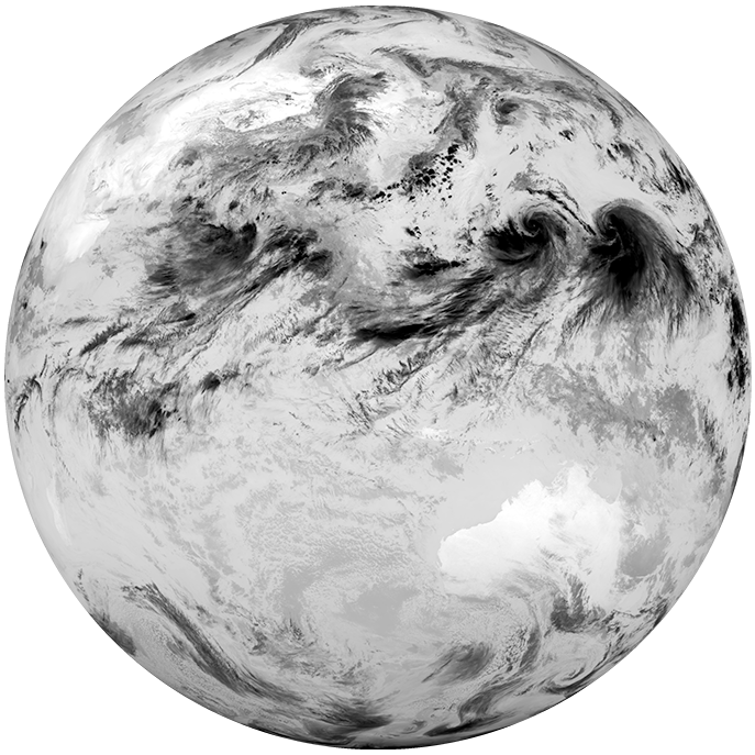
Loading ir_channel data:
# take the ir channel as example
ir_channel = 'C12'
scn.load([ir_channel], generate=False, calibration='brightness_temperature')
Full Disk Image
# display in notebook
scn.show(ir_channel)

# save to file
# scn.save_dataset(ir_channel, filename='{sensor}_{name}.png')
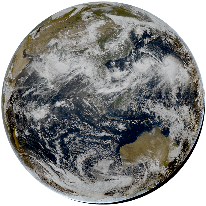
True color Image
# get a list of all available composites for the current scene
scn.available_composite_names()
Output:
['ash',
 'dust',
 'fog',
 'green',
 'green_snow',
 'ir108_3d',
 'ir_cloud_day',
 'natural_color',
 'natural_color_sun',
 'night_background',
 'night_background_hires',
 'overview',
 'overview_sun',
 'true_color']
Loading true_color:
#Beware that this step might need much memory available on the processing machine (depending on the number of cpu cores)

composite = 'true_color'
scn.load([composite])
scn.show(composite)
# scn.save_dataset(composite, filename='{sensor}_{name}.png')
Required file type 'agri_l1_4000m_geo' not found or loaded for 'satellite_zenith_angle'
Required file type 'agri_l1_4000m_geo' not found or loaded for 'satellite_azimuth_angle'
Required file type 'agri_l1_4000m_geo' not found or loaded for 'solar_azimuth_angle'
Required file type 'agri_l1_4000m_geo' not found or loaded for 'solar_zenith_angle'

Region of Interest
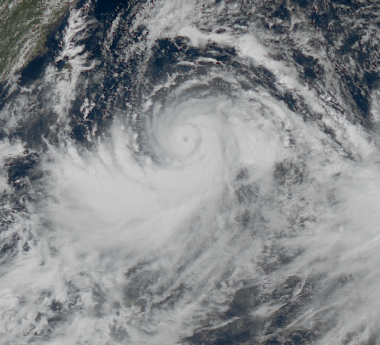
I take the typhoon LEKIMA as an example.
We can define a map-projection and a sub area, and project the data on this area.
Pyresample can be used to define the area easily.
This definition can also be put in the area.yaml configuration file.
from pyresample import get_area_def

area_id = 'lekima'

x_size = 549
y_size = 499
area_extent = (-1098006.560556, -967317.140452, 1098006.560556, 1026777.426728)
projection = '+proj=laea +lat_0=19.0 +lon_0=128.0 +ellps=WGS84'
description = "Typhoon Lekima"
proj_id = 'laea_128.0_19.0'

areadef = get_area_def(area_id, description, proj_id, projection,x_size, y_size, area_extent)
You can generate the area easily by coord2area_def.py
Here’s the output of python coord2area_def.py lekima_4km laea 10 28 118 138 4:
lekima_4km:
  description: lekima_4km
  projection:
    proj: laea
    ellps: WGS84
    lat_0: 19.0
    lon_0: 128.0
  shape:
    height: 499
    width: 549
  area_extent:
    lower_left_xy: [-1098006.560556, -967317.140452]
    upper_right_xy: [1098006.560556, 1026777.426728]
Now, you can add the configuration to $PPP_CONFIG_DIR/areas.yaml and use it directly
# If you have added it to areas.yaml, you can use the name directly:
os.environ['PPP_CONFIG_DIR'] = '/yin_raid/xin/satpy_config/'
lekima_scene = scn.resample('lekima_4km')

# Otherwise, you need to use the areadef defined above:
# lekima_scene = scn.resample(areadef)
lekima_scene.show(composite)
# lekima_scene.save_dataset(composite, filename='{sensor}_{name}_resampled.png')

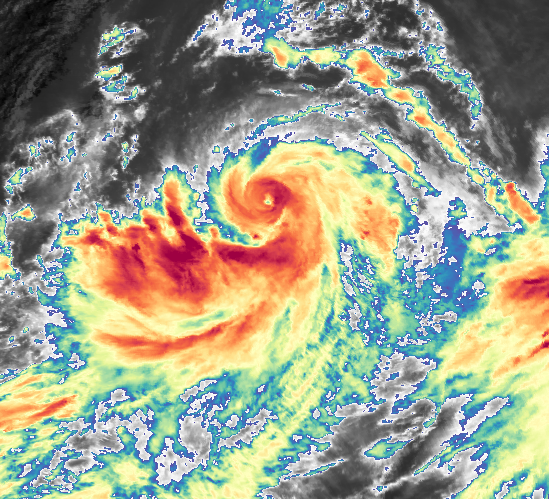
If you want to generate pictures with specific colormap like the figure below,
please check another notebook about enhancement.

References
- Notebooks: https://github.com/zxdawn/FY-4/tree/master/satpy/examples
- Satpy examples: https://satpy.readthedocs.io/en/latest/examples.html
- Presample: http://pyresample.readthedocs.org/
- Pytroll: http://pytroll.github.io/
Version control
| Version | Action | Time |
|---|---|---|
| 1.0 | Init | 2020-02-06 |

Say something
Thank you
Your comment has been submitted and will be published once it has been approved.
OOPS!
Your comment has not been submitted. Please go back and try again. Thank You!
If this error persists, please open an issue by clicking here.